MINAKI ENVIRONMENT & HERITAGE

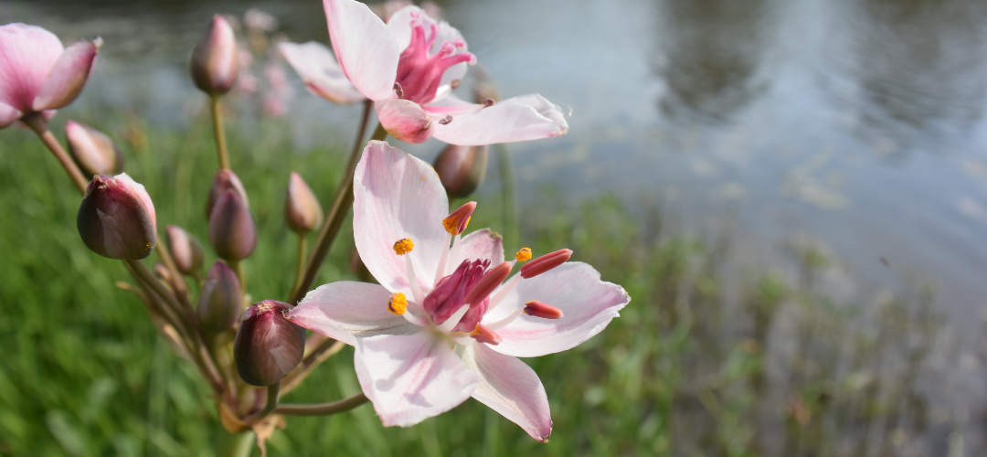
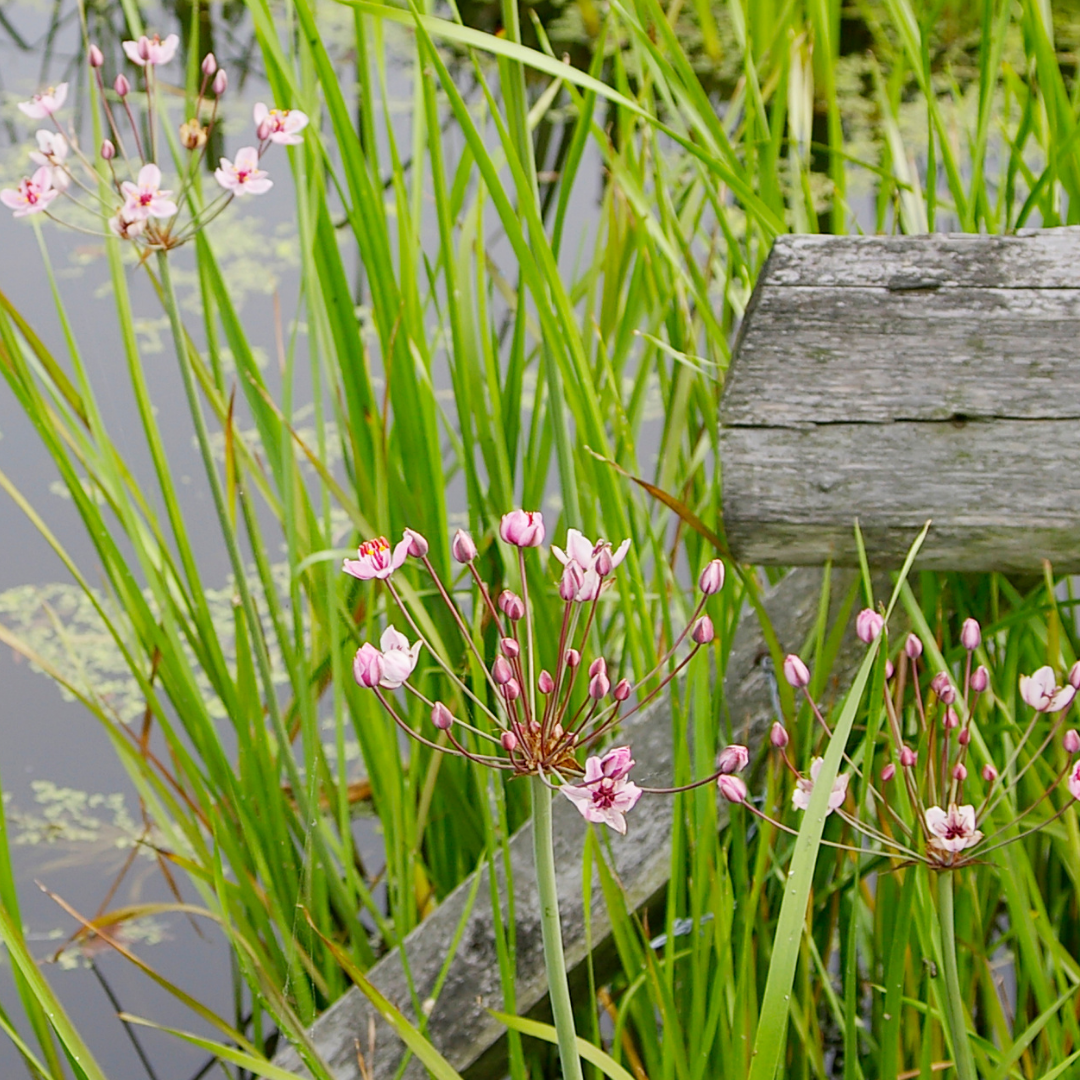
Flowering Rush (Butomus umbellatus), a non-native invasive aquatic plant, was first sighted in the Winnipeg River around Minaki 20 years ago. It has since spread rapidly, growing along many shorelines and filling shallow bays and channels.
Today, working with area property owners to control and ultimately halt its spread has become a primary focus of The Minaki Conservancy, in addition to lobbying local, provincial, and federal agencies to address the problem and assist in eradicating this environmentally devastating plant.
Property & Business Owners
Don Engebretson of The Minaki Conservancy shared a presentation on how to control the spread of Flowering Rush around docks and shorelines, presented on July 10, 2023.
Further, it is vital that members of the Minaki community report sightings of Flowering Rush. At the conclusion of this article, you will find instructions on how to do so.
History
Flowering Rush is native to Europe and Asia. It was first noted in North America in the St. Lawrence River in 1897. It may have been imported for sale as an ornamental plant. The plant then entered the Great Lakes via seed and root fragments in the ballast water of cargo ships. From there it steadily spread west. Flowering Rush is now found in every province and state along the Canadian/United States border.
Habitat & Identification
Flowering Rush grows in fresh water in depths of a few centimetres to three meters. It expands via thick, creeping rhizomes, which when disturbed break off to form new plants. The rhizomes also produce small bulblets that break off and take root. The plant flourishes in cool water and spread most rapidly in water with current.
The plant’s slender, pointed green leaves are visible approximately one-half to one meter above the surface. Leaves are noticeably narrower and shorter than native Ontario aquatic rushes, in addition to growing further from shore and in much deeper water. The sure way to identify Flowering Rush is to cut off a leaf. If the cross-section is triangular, the plant is Flowering Rush, as all Ontario native aquatic rushes will have flat, two-sided leaves.
The plant is easy to identify when in flower from late July to mid-September. Umbrella-shaped clusters of pink, upright flowers emerge from round stems held just above the tips of the leaves. Seeds produced in late summer are usually not viable in northern regions.
Environmental Impact
Flowering Rush disrupts the natural cycle of waterways. The dense underwater foliage clogs shorelines, bays and channels. The shoreline–to –three-meter depth zone is home to aquatic weed, insect, crustacean and minnow populations, all vital food sources for heron, duck, otter and muskrat. It is where wild rice grows. Minnows and walleyes spawn in this zone, while all Ontario fish species rely on the food produced there. Stocking programs in rivers in the United States have been implemented due to loss of food and spawning habitat caused by Flowering Rush.
The plant’s growth adversely affects recreational boating, swimming and fishing. In several lakes in Northern Minnesota, Flowering Rush has been so persistent it has reduced cottage property values.
Control & Eradication by Property Owners
NOTE: If you haven’t already, watch Donald Engebretson’s presentation from July 10, 2023 on how to halt the spread of Flowering Rush along the docks and shorelines. You can view the video here.
Manually cutting the leaves below the surface is effective for keeping areas around docks navigable, as well as improving the appearance of the shoreline. Tools for cutting lake weeds, (Weed Razor is one) have proved effective. The blades must be kept sharp, and one must be careful to cut, not pull up, the plant. Cutting the plant as close to the bottom as possible with sharp sheers or a sharp knife is also effective.
It is vitally important to remove all cuttings from the water. They float. Cuttings must then be deposited on shore above high water levels.
Removal by cutting two to three times per season will knock the plant back, but not eradicate it. Plants must be cut every two weeks for multiple seasons before cutting kills the plant rhizomes.
Pulling Flowering Rush from the river (or lake) bottom is an effective, although time-consuming, control method. However, it is ESSENTIAL that ALL plant material collected via pulling is corralled and brought to shore. The reason that pulling Flowering Rush is usually considered taboo in articles on the topic is that many property owners, unaware of the alien and invasive nature of the plant, began pulling it without removing it from their body of water. It was left to float away, where currents and wind delivered it to new shorelines and bays, thus spreading the infestation.
If you pull Flowering Rush from the river or lake bottom and ensure that every bit of the plant that comes up (especially broken rhizomes) is safely brought to shore, you are not contributing to its spread. Again, watch the video provided in this article for more on how to properly pull Flowering Rush.
Given the labor involved in cutting back flowering rush by hand, property owners may be tempted to think about use of an aquatic herbicide. The Ministry of the Environment, Conservation and Parks has confirmed with the Conservancy, however, that it is unlawful for a property owner to spray any herbicide on an aquatic plant in the Winnipeg River. Any spraying of flowering rush may be done only by a herbicide contractor licensed by the Ministry and with a permit from the Ministry for that specific application and location.
Tracking The Spread
A primary duty of all Conservancy members this summer, and for summers to come, is to submit reports of flowering rush sightings along the Winnipeg River. Our battle against flowering rush is only beginning. Documenting the extent of flowering rush in the river is a crucial, preliminary step in achieving our goal of receiving provincial and federal aid to fight this battle.
EDDMapS
(Early Detection Distribution Mapping System)
An online reporting tool and free mobile application where users can report sightings, review distribution maps, and explore educational resources of aquatic invasive species.
The Invasive Species Hotline
A toll-free telephone number where individuals can report sightings verbally.
-
Shoot three to four photos of the infestation. Take one of the entire infested area, one from mid-range, and two close-ups of an individual plant. If the plant is in bloom, shoot the bloom. If not, shoot a close-up of the foliage with the tip in the photo. Photos are NOT required when submitting a report, but help confirm that the plant is indeed flowering rush. Please read the article, if you haven’t. This will help you to identify the plant.
Visit the EDDMapS website. (Early Detection Distribution Mapping System.)
Click on “Report Sightings” in the menu at top. A login request will appear if you’ve not yet created an account. Fill in your email, create a password, then click on “Plants.”
The page will expand to list US states and Canadian provinces. Click on “Ontario.” Now you are ready to create and submit your report under the three main headings: Species, Infestation, and Location.
SPECIES: From the drop-down menu of invasive species, click on “flowering rush.”
INFESTATION: Complete the other fields— Infested Area, Survey Area, Habitat, Percent Cover, Abundance.
LOCATION: “Ontario” will already be filled in; use the drop-down menu under “State” and select “Kenora.” Don’t worry about Latitude and Longitude, those fields will fill in as you move next to mark the flowering rush infestation on the map.
Click on the Full Screen icon in the upper-right corner of the map to expand it to full screen. Expand the map with the “+” sign while dragging it with your cursor so that Minaki is in the center. As you continue to expand the map and move it with your cursor, you can zoom way in on the area of infestation you are reporting. You can make one island or a small bay fill the screen.
Now, mark the area of infestation on the map. In the upper-left corner, you will see a box with four icons, to the right of “Map/Satellite.” The four icons are a little hand, a pin, a zigzag line that looks like an “N,” and an odd shape. I’ve found the best to use is the “N.” Click on it.
Most often, the infestation you are reporting is a length of shoreline, or portion of a bay. Move your cursor to a starting point on the shoreline, give a click, then as you move your cursor along the shoreline, you will see it creating a red line. Click at any point where the shoreline zigs or zags, then continue to move your cursor along the shoreline, and you should see the red line continue in the new direction. When you come to the end of the shoreline portion of the infestation, move out to deeper water with your cursor. Always give a click when you wish to change direction of the line. The red line should follow. Continue to “draw” your red line until you return to your starting point. Clicking there will end the red lines. You have now created a single red line that encompasses the entire infestation.
This can require a little trial and error, and I haven’t found a way to clear the lines if you need to start over. But you can accomplish this by clicking back one page, then clicking on “Plants” again. After you get the hang of “drawing” the red lines, it’s simple. Just remember to end your red line at the start of your red line.
If it is a very small infestation, say the size of a pool table, you can also drop a pin. However, you can only drop one pin on the map. Drop a second pin, and it replaces the first pin.
FINAL STEPS: Below the map, you will see a section where you can download your photos. Also, a box for Comments, Identified By, and Location (Winnipeg River near Minaki is good).
Once all fields are completed, click “Submit Report.”

How many reports can you, Mr./Ms. Conservancy member, submit this summer?
They don’t take long. Make your goal five this summer. If we can crush the EDDmapS site with 1,000 sightings, you will help make a difference.
Scientists and other environmentalists within the Ontario Provincial and Federal governments monitor this site in their efforts to monitor, fund, and combat invasive species. This is an important duty for all Minaki Conservancy members.
You’ll see flowering rush breaking the surface in our beloved Winnipeg River in June. Get on it!
The above information was provided by Donald Engebretson.
Forestry
The Minaki Conservancy’s first initiative was the review of and comment on the ten-year forest management plan proposed by the Ministry of Natural Resources for 2006 through 2015, with a focus on the first five-year implementation. That initiative was a major undertaking, but it established the “no see – no hear” principle for logging plans and practices in the Minaki area and established The Conservancy as a recognized participant in forestry management matters going forward. Forestry consultant David Anderson advised The Conservancy in that effort.
In 2011, The Conservancy insisted that the “no see – no hear” values be included in a second five-year implementation of the 2006 plan. It also conducted an annual review on the ground of compliance of the actual cutting and road building with the requirements of the various plans.
In 2016, The Conservancy worked with MNR on the next ten-year plan. That plan so far includes two areas affecting Minaki — one near Pistol Lake and another around the entrance to Roughrock. The areas are shown on the map below.
In 2021, the Conservancy continues to partner with the Ontario Ministry of Natural Resources and Forestry (MNRF) and the Miisun Integrated Resource Company on the Kenora Forest Management Plan.
The policy of “no see - no hear” continues, as does regular consultation with our partners on the draft Forest Management Plan for 2022 - 2023.
Minaki Lodge
For over ten years, beginning in the fall of 2010, the Conservancy devoted significant time and resources to issues associated with proposed high-density residential redevelopment plans for the property on the Winnipeg River that held the Minaki Lodge and its golf course. From the start, the Conservancy worked jointly with representatives of a large group of year-round residents of the town of Minaki who shared concerns about the negative impacts of the redevelopment proposals.
That joint effort continued until the spring of 2021, when a group led by Doug and Glen Gratton, permanent residents of Minaki, purchased the property. The Gratton group has proposed a sensible residential density for the site, based primarily on single family dwellings available for year-round use on existing lots, and no use of the treatment plant.
With the property headed toward a good re-use, the following is a look back at the Conservancy's and the year-round residents' joint work over a long haul on the critical Lodge site.
In late September, 2010, Steinbach real estate developer Bob Banman came to a community meeting in Minaki, announced that he and fellow Manitoba developer Bob Schinkel were acquiring the Minaki Lodge property, and showed plans to put 161 seasonal residential condominium units on the site. The then 25-year old Minaki Lodge private sewage treatment plant would handle all the sewage and wastewater from the project.
For a large number of year round residents of the town of Minaki and for the Conservancy (then known as the Minaki Cottagers Association), the scale and density of the condominium proposal raised a set of significant concerns regarding (1) the proposed treatment of sewage from the redevelopment in unorganized territory, (2) the adverse impacts of the extreme density of proposed condominium units on Minaki’s natural environment, special character and setting, and tourism industry, (3) the danger to public safety from the excessive number of boats and docks and amount of water recreation in the Lodge channel, and (4) the loss of the significant cultural heritage of the Minaki golf course landscape.
Attempts to discuss the concerns with developers in late 2010 were not productive. Over the next six years, the residents and the Conservancy (then representing over 380 seasonal residents) presented their concerns to the Ministry of Municipal Affairs and Housing, which held an approval over the property subdivision that was required for the condominium use. Those concerns were backed by reports of independent experts on planning, sewage treatment, and cultural historical landscape. The Wabaseemoong Independent Nation at Whitedog and the Niisaachewan Anishinaabe Nation at the Dalles also expressed concerns directly to MMAH.
Over the same period, the Conservancy corresponded with mixed success with the Ministry of the Environment, which had erroneously assigned to developers the former Minaki Lodge sewage treatment permit without updating its terms from 1988, including the piping of effluent directly into the Winnipeg River.
In April, 2016, MMAH approved the redevelopment condominium applications. The group of year-round residents and the Conservancy appealed that approval to the Ontario Municipal Board. After a two-week hearing in July, 2017, in Kenora, the OMB reversed the MMAH approval, ruling that private communal sewage treatment of the kind proposed by developers for the condominium units could not occur in unorganized territory. The Independent Nations and the Lake of the Woods District Stewardship Association helped with appearances at the hearing.
Developers appealed the ruling to the chair of the OMB, who affirmed the hearing result in May, 2018. A community effort to buy the Lodge site from developers, over the summer of 2018, foundered on environmental issues associated with the property.
Developers then turned to a plan for a trailer park, with 198 units. Trailer park use required no land subdivision, and MMAH approval was not required. Developers proposed again to run all waste through the sewage treatment plant, and in 2019 applied for an amendment to the treatment permit from the Ministry of the Environment, Conservation and Parks to accommodate the changed use. The Conservancy, the group of year-round residents, and the Niisaachewan Anishinaabe Nation again attempted, again unsuccessfully, to convince MECP to end the direct dumping of effluent into the Winnipeg River.
With the MECP approval in hand, developers announced the offering of the site for sale for trailer park use in the fall of 2020. A sale for that use did not materialize, and six months later the Gratton group acquired the property instead.
The years of effort on the MMAH and MECP approvals and the OMB hearing involved significant third party costs for expert reports, legal fees, and travel, all funded by donations from Conservancy members and year-round residents. The result is that even in a small place like Minaki, a broad, cooperative, and persistent approach can step up to meet a major challenge.